Imagine looking at your primary flight display and seeing not just lines and numbers, but a vivid, three-dimensional world. A world where terrain rises in realistic detail, runways appear exactly where they should be, and your flight path is painted as a clear highway in the sky, This is the reality offered by a Synthetic Vision System (SVS), a revolutionary avionics technology that has redefined cockpit situational awareness and safety. More than just an enhanced map, SVS is a certified flight deck system that provides a continuous, computer-generated visual reference of the external environment, fundamentally changing how pilots navigate and perceive their flight.
What is a Synthetic Vision System (SVS)?
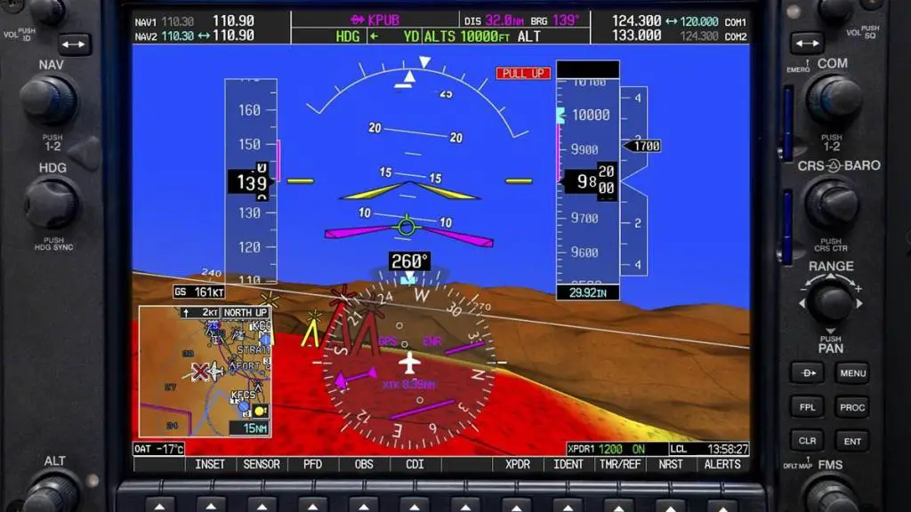
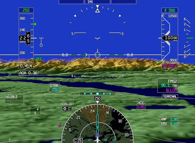
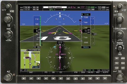
A Synthetic Vision System is an integrated cockpit avionics suite certified to display a real-time, perspective view of the external topography, cultural features, obstacles, and flight path on a Primary Flight Display (PFD) or a dedicated display. Unlike a simple database map, SVS fuses precise aircraft position and attitude with a high-integrity global terrain database to generate a conformal, intuitive 3D image. This “synthetic view” acts as a continuous visual reference, dramatically reducing the pilot’s workload of constructing a mental picture from traditional instruments.
A certified SVS display is characterized by several key elements:
- Photorealistic or Symbolic Terrain Depiction: Rendered terrain is often color-coded for altitude (e.g., green for at or below aircraft altitude, yellow for caution, red for threat).
- Cultural Features: Accurate representations of runways, taxiways, roads, rivers, and urban areas are embedded.
- Obstacle Data: Towers, buildings, and other charted hazards are clearly depicted.
- Conformal Flight Symbology: Critical flight instruments like the pitch ladder, flight path vector, and heading tape are overlaid directly onto the synthetic scene, moving as if they are part of the outside world.
- Pathway Guidance: Many systems include a “Highway in the Sky” (HITS) or similar tunnel-in-the-sky display, providing intuitive spatial guidance for navigation and approach.
How a Synthetic Vision System Works
An SVS performs a complex, real-time fusion of data to create its seamless display. Here is a step-by-step breakdown of the process:
- Precise State Determination: The system first establishes the aircraft’s exact position and orientation in space. It uses a high-integrity attitude and heading reference system (AHRS) or inertial reference system (IRS) for pitch, roll, and heading, coupled with a high-accuracy GPS receiver for latitude, longitude, and altitude. This data stream is validated for integrity.
- Database Interrogation: Using this precise state data, the system’s computer queries its onboard databases. These are not simple charts but massive, validated files:
- Terrain Database: A global digital elevation model detailing the earth’s topography.
- Obstacle Database: Contains the location and height of man-made obstacles.
- Cultural Database: Includes airports, runways, roads, railroads, and water features.
- Image Generation & Rendering: The core computer generates a 3D, egocentric (from the pilot’s viewpoint) perspective of the world ahead. It renders the terrain mesh, applies color based on the aircraft’s current altitude, and inserts the cultural and obstacle features. This rendering happens at a high refresh rate to provide fluid, real-time motion.
- Symbology Integration & Display: The final step is the conformal overlay of primary flight display symbology (the airspeed tape, altitude tape, flight path marker, and the Highway in the Sky guidance) onto the synthetic scene. This integrated picture is then presented on the high-resolution cockpit display.
Why SVS is a Safety Imperative
The value of a certified SVS extends far beyond visual appeal. It directly targets and mitigates some of the most persistent risk factors in aviation.
- Revolutionized Situational Awareness (SA): SVS provides an immediate, accurate, and intuitive understanding of geographic position, terrain proximity, and airport environment. It eliminates the high cognitive workload of mentally translating 2D charts, round dials, and a moving map into a 3D model, especially during high-stress phases like approach in mountainous terrain or at an unfamiliar airport at night.
- Powerful CFIT Mitigation: By providing continuous, glanceable terrain awareness with clear caution and warning color coding, SVS is one of the most effective tools ever developed to prevent Controlled Flight Into Terrain accidents. Pilots can see terrain conflicts developing long before an audible warning might sound.
- Spatial Disorientation Defense: The compelling, attitude-stabilized visual reference is a powerful antidote to vestibular illusions that can occur during instrument flight, at night, or in featureless conditions (e.g., over water or in haze).
- Reduced Workload and Pilot Stress: The intuitive display lowers the mental effort required for navigation and terrain awareness, freeing up pilot capacity for systems management, communication, and decision-making. This reduces fatigue and increases confidence, particularly in single-pilot operations.
- Enhanced Procedural Adherence: The Highway in the Sky guidance provides intuitive spatial command guidance, making it easier for pilots to fly precise departure, en route, and approach procedures, ultimately supporting stabilized approaches.
Critical Limitations and Pilot Responsibilities
For all its power, a Synthetic Vision System has inherent limitations that pilots must thoroughly understand and respect. SVS is an aid to, not a replacement for, skilled instrument flying and sound judgment.
- Database Limitations: The system is only as accurate and current as its installed databases. It does not detect real-world, dynamic objects like other aircraft, weather, vehicles on a runway, or un-charted obstacles (e.g., new construction cranes). Database updates are crucial.
- Not a Primary Flight Instrument: Regulatory authorities certify SVS as a supplemental display. Aircraft control must be maintained using the certified primary flight instruments (the attitude indicator, airspeed indicator, altimeter, etc.), even when they are presented within the SVS scene. Pilots must avoid “heading down” fixation on the synthetic view.
- System Integrity Reliance: The entire display depends on the flawless operation of GPS, AHRS, and database loading. Any failure or corruption in these inputs can produce a misleading, and potentially hazardous-display.
- Complacency Risk: An over-reliance on the synthetic view could lead to a degradation of basic instrument scan skills or a disregard for actual out-the-window visual cues when they are available.
The Future of Synthetic Vision System
- Enhanced Vision Systems (EVS): Use an infrared (IR) or millimeter-wave radar camera to display a real-time, sensor-based image of the actual terrain and runway environment through fog, darkness, or precipitation.
- Combined Vision Systems (CVS): The ultimate integration, which merges the real-time sensor image from an EVS with the database-driven certainty of the SVS into a single, enhanced, and intuitive display on the PFD. This combined system can form the basis for Enhanced Flight Vision Systems (EFVS) that allow for lower landing minima and greater operational flexibility.
Frequently Asked Questions (FAQs)
Q1: What’s the difference between SVS, SVT, and EFVS?
A: Synthetic Vision Technology (SVT) often refers to the general display capability, sometimes as a non-certified feature. A Synthetic Vision System (SVS) is a fully certified, TSO’d avionics suite using a terrain database. An Enhanced Flight Vision System (EFVS) is a certified operational system that uses sensor imagery (like IR) to allow descent below published minimums on an approach. EFVS often uses an SVS as a background layer.
Q2: Can I retrofit an SVS into my older aircraft?
A: Yes. Many aftermarket avionics upgrades now include certified SVS capabilities. Popular examples include the Garmin G500 TXi, G3X Touch (for experimental/light-sport), and Aspen Avionics MAX series displays. Retrofits require installation of compatible displays, sensors (AHRS, GPS), and database subscriptions.
Q3: Does the FAA recognize the safety benefits of SVS?
A: Absolutely. The FAA has actively supported SVS development and certification. While it does not yet permit lower minima for SVS alone (that requires an EFVS using sensors), the agency acknowledges its significant role in improving situational awareness and reducing CFIT risk. SVS is a key component of many modern Safety Management System (SMS) proposals for operators.
Q4: Do I need special training to use an SVS?
A: While not always legally mandated, comprehensive training is essential. Pilots must move beyond basic “how it works” to “how it fails” and “how to integrate it.” Training should focus on scanning techniques that incorporate the SVS picture without fixating on it, understanding its limitations, and practicing procedures for database or system failures.
Q5: How often do the terrain and obstacle databases update?
A: This varies by manufacturer and service plan, but typical update cycles are 28 or 56 days, aligning with the AIRAC cycle for navigation databases. It is the pilot’s responsibility to ensure databases are current.
Q6: Can SVS display traffic and weather?
A: Advanced SVS implementations can integrate this data. When paired with ADS-B In, traffic targets can be displayed as conformal symbols overlaid on the synthetic terrain. Similarly, datalink weather (NEXRAD, METARs) can be integrated, providing a comprehensive situational awareness picture on a single display.


Leave a comment