
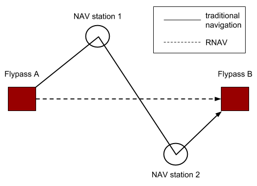
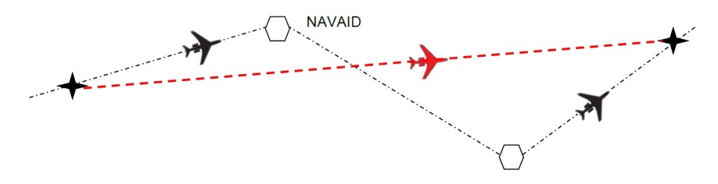
A flight from Chicago to Miami might first detour to a beacon in Indianapolis, then another in Atlanta, adding extra miles, burning excess fuel, and wasting precious time. This all changed with the advent of Area Navigation (RNAV), a revolutionary concept that freed aircraft from the tyranny of fixed ground stations.
RNAV is the technological magic that allows modern aircraft to fly directly from point A to point B, creating efficient, flexible flight paths that save time, fuel, and money, while simultaneously increasing airspace capacity and reducing environmental impact. It is the foundational principle behind the quiet, precise, and efficient air travel we experience today.
What is RNAV?
RNAV (Area Navigation) is a method of instrument flight that allows an aircraft to choose any desired course within the coverage of station-referenced navigation signals or within the limits of a self-contained system capability. In simple terms, it enables an aircraft to fly on a direct path between two geographic coordinates, known as waypoints, without having to overfly ground-based navigation aids like VORs or NDBs.
Think of the old system as a train that can only travel on fixed tracks between stations. RNAV turns the aircraft into a car, capable of driving directly to its destination using any route it chooses, as long as it has the right “map” and “navigation system.” These waypoints are defined by latitude and longitude, creating a virtual network of points in the sky that aircraft can navigate between with precision.
Start your Airbus A320 Type Rating with this book “click here“
How RNAV Systems Work
An RNAV system is essentially a computer, a “Flight Management System (FMS)” that uses data from multiple sensors to calculate the aircraft’s position and then guide it along a predefined path. The system does this through a continuous process:
- Position Determination: The FMS continuously computes the aircraft’s present position. It does this by synthesizing data from various sources, primarily:
- GNSS (Global Navigation Satellite System): GPS is the most common and accurate sensor used for RNAV today.
- DME/DME: The system can calculate its position by triangulating its distance from two or more Distance Measuring Equipment (DME) ground stations.
- VOR/DME: Using a combination of bearing from a VOR and distance from a co-located DME.
- Inertial Reference Systems (IRS): These self-contained systems use gyroscopes and accelerometers to calculate position based on movement from a known starting point.
- Flight Path Computation: The pilot or airline dispatcher programs the desired route into the FMS, which is a sequence of waypoints. The computer knows the exact location of each waypoint.
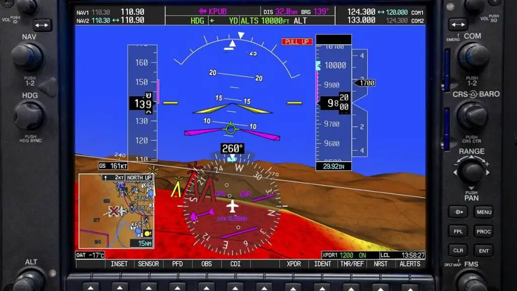
- Guidance and Display: The FMS compares the aircraft’s computed position to the desired path between waypoints. It then generates steering commands to the autopilot or displays guidance to the pilot on the Horizontal Situation Indicator (HSI) or Navigation Display (ND), showing exactly how to stay on the “purple line” of their intended course.
RNAV vs RNP: Understanding the Difference
While often used interchangeably, RNAV and Required Navigation Performance (RNP) have a crucial technical distinction that pilots and operators must understand.
| Feature | RNAV (Area Navigation) | RNP (Required Navigation Performance) |
|---|---|---|
| Core Definition | A capability to fly any desired path. | An RNAV system that includes onboard performance monitoring and alerting. |
| The Key Question | “Is the aircraft on the correct path?” | “Is the aircraft on the correct path, and can the system guarantee it is within the required accuracy?” |
| Onboard Monitoring | Not Required. The system may not be able to determine if its accuracy has degraded. | Required. The system continuously monitors its own navigation performance and will alert the pilot if it cannot remain within the specified containment limits (e.g., RNP 0.3 means within 0.3 nautical miles). |
| Typical Use | En-route and terminal operations (e.g., RNAV 1 SIDs and STARs). | More complex and demanding procedures, such as specific approach procedures (RNP APCH) or routes through difficult terrain (RNP AR). |
The Simple Analogy: Think of RNAV as a car with a basic GPS that shows your position on a map. RNP is that same car, but with an advanced system that also monitors the car’s steering and will sound an alarm if it detects you are about to unintentionally drift outside your lane. This “guarantee” of performance is what allows RNP procedures to be designed through challenging terrain or in dense airspace with tighter tolerances.
How RNAV Benefits Everyone
The implementation of RNAV has delivered profound benefits across the aviation industry:
- For Airlines (Efficiency & Cost):
- Shorter Routes: Direct routing saves vast amounts of fuel. A single flight can save hundreds of kilograms of fuel, translating to lower costs and increased profitability.
- Optimized Climbs/Descents: RNAV allows for Continuous Descent Approaches (CDAs), where an aircraft descends from cruise altitude with engines at idle, significantly reducing noise and fuel burn.
- Increased Schedule Reliability: More predictable flight times.
- For Air Traffic Control (Capacity & Safety):
- Increased Airspace Capacity: By creating precise, parallel routes, ATC can safely pack more aircraft into the same volume of airspace.
- Reduced Communication: With aircraft flying predictable, pre-programmed paths, controller-pilot communication is reduced, lowering workload.
- Improved Traffic Flow: RNAV procedures like Standard Instrument Departures (SIDs) and Standard Terminal Arrivals (STARs) create streamlined flows in and out of busy airports.
- For Passengers and the Environment:
- Reduced Emissions: Shorter, more efficient routes directly lead to lower carbon emissions.
- Noise Abatement: Precision flight paths allow for routing that minimizes noise over populated areas.
- Fewer Delays: A more efficient airspace network helps prevent cascading delays.
RNAV in Action
- Departure: An aircraft will often fly an RNAV Standard Instrument Departure (SID), a published procedure that guides it away from the airport and into the en-route structure with extreme precision, often avoiding noise-sensitive areas.
- En-Route: In cruise, the aircraft follows an optimized route defined by RNAV waypoints, often flying “great circle” routes that represent the shortest distance between two points on the globe.
- Arrival: The aircraft will fly an RNAV Standard Terminal Arrival (STAR), a streamlined procedure that feeds traffic from the en-route phase toward the destination airport.
- Approach: Many airports now have RNAV (GPS) Approach procedures. These allow aircraft to perform an instrument approach to a runway without needing a ground-based ILS, granting all-weather access to thousands more airports worldwide.
RNAV FAQs
1. Do all aircraft have RNAV capability?
Today, virtually all commercial airliners and a vast majority of business and general aviation aircraft are equipped with RNAV capability. The specific level of capability (e.g., RNAV 1, RNP 0.3) depends on the installed avionics and its certification.
2. What does “RNAV 1” mean?
The number (e.g., 1, 2, 5) indicates the navigation accuracy requirement in nautical miles. For RNAV 1, the aircraft must be able to maintain a flight path within a 1 nautical mile tolerance for 95% of the flight time. This is typical for terminal airspace (SIDs and STARs).
3. Is RNAV the same as GPS?
No, but GPS is the primary sensor that enables modern RNAV. RNAV is the capability, while GPS is one of several technologies that can provide the position data to achieve that capability.
4. As a passenger, how can I tell if my flight is using RNAV?
You can’t directly, but you can infer it. If you are using a flight tracking app and see your aircraft flying a perfectly straight line over the ground, not zig-zagging between radio stations, it is almost certainly using RNAV. Smoother, more continuous turns during climb and descent are also indicators.
5. What training is required for pilots to use RNAV?
Pilots undergo specific training to understand the Flight Management System, program routes, and monitor the navigation performance. They are trained to recognize and respond to system failures or degradations.
6. What happens if the RNAV system fails?
Pilots are trained to revert to other means of navigation. They would inform Air Traffic Control, who may then provide radar vectors or clear the aircraft to navigate using traditional ground-based navaids (VORs).


Leave a comment