
With no runways in sight and only a vast, featureless expanse of water below, the pilot relies on a steady, precise signal to find the moving target that will become their landing strip. This is the domain of TACAN, the Tactical Air Navigation system. While its civilian cousin, VOR, has guided commercial flights for decades, TACAN has been the military’s trusted, high-precision navigator, built for the dynamic and demanding environments of defense aviation.
It’s a system that provides not just direction, but exact distance, enabling formation flying, aerial refueling, and carrier landings with remarkable accuracy. This is the story of the robust, resilient technology that empowers military aviation to operate with pinpoint precision anywhere on the globe.
Start your Airbus A320 Type Rating with this book “click here“
What is TACAN?
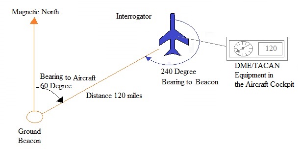
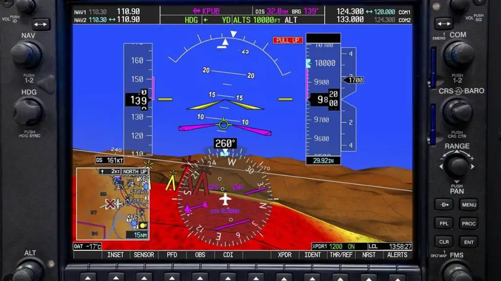
TACAN is an ultra-high-frequency (UHF) radio navigation system designed primarily for military use. It provides a pilot with two critical pieces of information: slant-range distance and magnetic bearing to a ground-based or ship-based station. Operating in the 960-1215 MHz frequency band, TACAN is known for its superior accuracy and resistance to signal reflection (a phenomenon known as “site error”) compared to civilian systems. Its defining feature is the integration of distance and direction into a single, compact unit, a capability that was revolutionary at its inception and remains vital today.
Think of a TACAN station as a lighthouse that not only tells you which direction it’s in but also precisely how far away you are. This gives a military aircraft a complete polar coordinate fix from a single point, a crucial advantage in tactical situations where simplicity and speed are paramount.
How TACAN Works
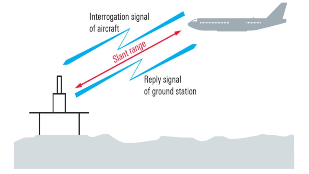
TACAN’s operation is a masterpiece of precision timing and signal processing. The system is built on a pulse-based, two-way communication between the aircraft and the station.
- The Interrogation: The aircraft’s TACAN unit (the interrogator) transmits a stream of precisely timed pulse-pairs on a specific channel.
- The Reply: The ground or ship-based station (the transponder) receives these pulses and, after a fixed, minuscule delay, transmits its own stream of reply pulse-pairs back to the aircraft.
- Distance Calculation (DME): The aircraft’s unit measures the total time elapsed between sending its interrogation and receiving the reply. By subtracting the known ground delay and calculating the travel time of the radio waves, it determines the precise slant-range distance in nautical miles. This is the Distance Measuring Equipment (DME) component, which is functionally identical to the DME used with civilian VORs.
Simultaneously, the ground station transmits its bearing information.
- Bearing Calculation: The TACAN ground antenna is unique. It features a rotating element that creates a special modulation pattern in its transmitted signal. The aircraft’s receiver analyzes this pattern and compares it to a reference signal to determine the exact magnetic bearing from the station. This creates the 360 “radials,” just like a VOR, but with greater accuracy.
This combination of precise DME and highly accurate bearing from a single, compact system is what sets TACAN apart.
The Civil-Military Bridge: VORTAC
While TACAN was for the military and VOR/DME was for civilians, a practical solution was needed to allow all aircraft to share the same navigational infrastructure. The answer was VORTAC.
A VORTAC station is a co-located VOR and TACAN transponder. This ingenious combination provides three different services simultaneously:
- For Civilian Aircraft: They receive standard VOR bearing from the VOR portion and DME distance from the TACAN portion.
- For Military TACAN Aircraft: They receive both bearing and distance from the TACAN portion.
This means a pilot in a commercial airliner and a pilot in a fighter jet can both use the same VORTAC station for their navigation needs, each accessing the components compatible with their equipment. VORTAC stations are the most common type of navigational aid in the U.S. national airspace system, seamlessly bridging the civil-military divide.
TACAN in Action
Carrier Aviation:
This is TACAN’s most iconic application. An aircraft carrier is a TACAN station on the move. For a pilot returning to the “boat,” the TACAN provides a continuous, real-time readout of distance and bearing to the moving landing deck, which is absolutely critical for a successful “trap” (arrested landing).
Aerial Refueling:
During aerial refueling, the tanker aircraft can act as a mobile TACAN station. Receiving aircraft can use this signal to maintain a precise position relative to the tanker, ensuring a safe and stable connection for fuel transfer.
Formation Flying:
Flight leaders can use TACAN to provide navigational guidance to wingmen, who can use the leader’s TACAN signal to maintain their position in the formation, especially in poor visibility or at night.
Tactical Missions:
In combat scenarios, TACAN allows for precise coordination of aircraft, enabling timed arrivals on target, egress routes, and rendezvous points without relying on vulnerable external navigation systems.
TACAN vs. VOR/DME vs. GPS
| Feature | TACAN | VOR/DME | GPS |
|---|---|---|---|
| Primary User | Military | Civilian | Universal |
| Frequency Band | UHF (960-1215 MHz) | VHF (108-117.95 MHz VOR), UHF (DME) | L-Band (Satellites) |
| Accuracy | High (Bearing & Distance) | Moderate (Bearing & Distance) | Very High (Global Positioning) |
| Bearing Source | Integrated TACAN Station | VOR Ground Station | Satellite Constellation |
| DME Source | Integrated TACAN Station | Co-located DME Transponder | N/A (Provides Coordinates) |
| Platform | Fixed Ground, Ships, Aircraft | Fixed Ground Only | Space-Based Satellites |
| Vulnerability | Resistant to jamming, line-of-sight | Resistant to jamming, line-of-sight | Vulnerable to jamming/spoofing |
While GPS is now the primary means of navigation for both military and civilian aviation, TACAN’s role has shifted to that of a vital backup and a primary system for specific tactical applications where GPS denial is a real threat.
The Future of TACAN
In an era dominated by GPS, one might assume TACAN is obsolete. The opposite is true. The vulnerability of GPS to jamming and cyber-attacks has reinforced the value of TACAN as a resilient, reliable, and independent navigation system. Modern military aircraft are equipped with Inertial Navigation Systems (INS), GPS, and TACAN, creating a robust, multi-layered navigation suite. If GPS is lost, the aircraft can use TACAN fixes to update and correct its inertial system, maintaining navigation accuracy.
The future of TACAN is secure as a pillar of PNT (Positioning, Navigation, and Timing) resilience. It remains a critical tool for mission assurance, ensuring that military aviation can operate effectively even in contested electromagnetic environments.
TACAN FAQs
1. Can civilian aircraft use TACAN?
Generally, no. Civil aircraft are not equipped with TACAN bearing receivers. However, they can and regularly do use the DME portion of TACAN and VORTAC stations for distance information.
2. What is the difference between TACAN and VORTAC?
A TACAN is a purely military station providing bearing and distance. A VORTAC is a combined station that provides VOR bearing for civilians and TACAN bearing/distance for military aircraft, with both using the same DME for distance.
3. Why does the military use TACAN instead of just GPS?
While the military uses GPS extensively, TACAN provides a crucial independent backup. GPS signals are weak and can be jammed or spoofed. TACAN is a powerful, line-of-sight signal that is much harder to disrupt, ensuring navigation capability during electronic warfare.
4. How accurate is TACAN?
TACAN is highly accurate. Its bearing accuracy is typically within 0.25 degrees, a significant improvement over standard VOR. Its DME accuracy is comparable to civilian DME, generally within 0.1 nautical miles.
5. What does a TACAN channel number represent?
The TACAN channel number corresponds to a specific pair of UHF frequencies, one for transmitting and one for receiving. Pilots simply tune the channel number, and the aircraft’s equipment selects the correct frequencies automatically.
6. Can TACAN be used internationally?
Yes, TACAN is a standard NATO system and is used by military forces in many countries around the world, though its availability may vary by region.
7. Is TACAN being phased out?
No. While some ground stations have been rationalized, the system as a whole is being retained and modernized due to its resilience and critical role in military operations, especially in a GPS-denied environment.


Leave a comment