
Automatic Terminal Information Service (ATIS) works by broadcasting real-time details on weather, runways, and hazards, ATIS transforms potential radio congestion into orderly dialogue, making it one of the most indispensable yet understated technologies in modern aviation.
What is ATIS?
The Automatic Terminal Information Service (ATIS) is a continuous broadcast service that provides essential aeronautical information to pilots operating within terminal areas.
Available via voice or datalink, it delivers data on weather conditions, active runways, instrument approaches, and other critical operational details. Updated hourly or during significant changes, ATIS ensures all users access standardized information, reducing communication errors and frequency congestion.
Start your Airbus A320 Type Rating with this book “click here“

ATIS Evolution
1960s–1970s: Early Development
- The FAA pioneered ATIS to replace repetitive controller-pilot exchanges during high-traffic periods.
- Initial systems used analog recordings updated manually by controllers.
1980s–1990s: Automation Integration
- Digital systems emerged, integrating weather sensors and text-to-speech technologies.
- Datalink ATIS (D-ATIS) was introduced in 1996, enabling text-based transmissions via ACARS.
2000s–Present: Global Standardization
- ICAO mandates ATIS for international airports, with broadcasts in English and local languages.
- AI-driven systems now predict updates based on weather trends and traffic patterns.
How ATIS Works
1. Information Collection
- Sources include meteorological sensors (wind, visibility, temperature), runway monitoring systems, and NOTAM databases.
- Data is compiled into a structured script following ICAO standards.
2. Broadcast Channels
- Voice ATIS: Transmitted via VHF radio or navigational aids (e.g., VOR).
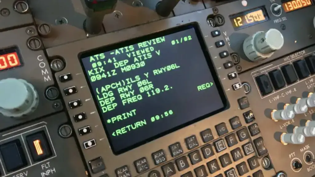
- Datalink ATIS (D-ATIS): Sent digitally to cockpit displays via ACARS or similar networks.
3. Update Protocols
- Updates are triggered by significant changes (e.g., runway switches, weather deterioration).
- Each broadcast is assigned a phonetic letter (e.g., Alpha, Bravo) for pilot confirmation.
4. Pilot Interaction
- Pilots listen to or download ATIS before contacting ATC.
- On initial contact, they confirm receipt by stating the phonetic code (e.g., “Information Bravo”).
Key Content of an ATIS Broadcast
ATIS messages include the following elements in standardized order:
- Airport Name and Phonetic Code
- e.g., “Dulles International Information Sierra.”
- Time of Observation
- Provided in Coordinated Universal Time (UTC).
- Weather Data
- Wind direction/speed, visibility, cloud layers, temperature, dew point, and altimeter setting.
- Operational Details
- Active runways, instrument approaches in use, and runway conditions.
- Advisories
- NOTAMs, bird activity, laser incidents, or taxiway closures.
Example:
“Boston Logan Information Delta. Time 1750Z. Wind 080° at 10 knots. Visibility 6 miles. Broken clouds at 3,000 feet. Temperature 12°C, dew point 8°C. Altimeter 29.92. ILS Runway 22R approach in use. Departure Runway 27. Advise on initial contact you have Information Delta.”
Voice vs Datalink ATIS
| Aspect | Voice ATIS | Datalink ATIS (D-ATIS) |
|---|---|---|
| Accessibility | Requires tuning to VHF frequency | Received automatically via datalink |
| Clarity | Prone to audio distortion | Text-based, eliminating mishearing |
| Workload | Pilots manually note details | Integrated into cockpit displays |
| Coverage | Limited to radio range | Global via satellite networks |
Why ATIS is Non-Negotiable for Aviation Safety
1. Workload Reduction
- Cuts controller-pilot communication by 40%, freeing frequencies for emergency coordination.
- Prevents repetitive weather broadcasts during peak traffic.
2. Error Prevention
- Standardized format ensures consistent interpretation across language barriers.
- Phonetic codes confirm pilots use current information.
3. Operational Efficiency
- Enables faster turnarounds with pre-departure access to runway and weather data.
- Supports rapid decision-making during weather changes.
4. Emergency Preparedness
- Alerts pilots to hazards like wind shear, laser incidents, or runway contaminants.
Global Variations and Adaptations
- Europe: Uses meters for visibility and hectopascals for pressure.
- North America: Reports visibility in miles and altimeter settings in inches of mercury.
- Remote Areas: Satellite-based D-ATIS ensures coverage in regions with limited ground infrastructure.
The Future of ATIS in Aviation
- Predictive ATIS
- AI algorithms will forecast updates based on weather models and traffic flow.
- Multilingual Support
- Real-time translation for non-English speaking pilots.
- Enhanced Datalink
- Integration with EFBs (Electronic Flight Bags) for seamless data flow.
- Cybersecurity
- Encryption protocols to prevent spoofing or data manipulation.
ATIS FAQs
How often is ATIS updated?
Broadcasts are updated hourly or during significant changes (e.g., wind shifts, runway closures). Controllers issue “special” updates for urgent changes.
What if I cannot receive ATIS?
Controllers will provide critical information (weather, runways) on initial contact. However, this increases frequency workload.
Can ATIS be wrong?
While rare, sensor errors can occur. Pilots should cross-check with METARs and PIREPs.
Why are phonetic letters used?
Letters (Alpha, Bravo, etc.) confirm pilots have the latest broadcast. The sequence resets after 12 hours of inactivity.
Do all airports have ATIS?
Primarily available at Class B, C, and D airports. Smaller fields use ASOS/AWOS for weather-only broadcasts.
How does D-ATIS work?
Data is transmitted via ACARS or similar networks to cockpit screens, reducing manual entry errors.
What’s the difference between ATIS and METAR?
ATIS includes operational details (runways, NOTAMs), while METAR is purely meteorological.


Leave a comment